Honeymoon trip to Yosemite National Park, California - Vernal Fall, Nevada Fall, Clouds Rest Trail
- Camilla Ho
- Jul 2, 2023
- 8 min read

Updated: Jan 12, 2025
Following our I Do's in June 2022, we embarked on another summer backcountry trip together. Yosemite National Park beckoned, and plans for a 5-night thru-hike was born! What was supposed to be a 5-night thru-hike anyhow - Yosemite had other plans for us. As many fellow backcountry hikers and campers can probably attest, even the most researched routes can be foiled by the unpredictability of the journey itself. This was one of those trips. Our journey turned into a daily dance with unexpected setbacks, changing itineraries, and the very real threat of forest fires. Grab your hiking boots and join us as we navigate together the twists and turns of our adventure in Yosemite!
Here we go!
Yosemite National Park - Honeymoon Edition
Route: Happy Isles, Little Yosemite Valley, Sunset Creek, Clouds Rest
Elevation of Clouds Rest: 9,926 ft (3,025 m)

Located on the traditional territory of the Ahwahnechee people, Yosemite National Park is massive with nearly 1,200 square miles to explore. We were most excited to reach high summits, wilderness camp, and be surrounded by beautiful ancient giant sequoias!
Gear wish list:
- Lightweight chair with a small backrest (we only had tripod stools - I don't find these comfortable at all after long treks). We ended up using our bear canisters a lot which was a great seat alternative!
Personal lessons:
- My legs are getting old and achy.
- Bring SPF lip balm. I've never had my lips burn and crack like they did on this trip!
Respect the park and tips for backcountry camping in Yosemite:
- Follow Leave No Trace principles, including packing out your toilet paper
- Bear spray is prohibited in Yosemite National Park.
- Bear canisters are required when overnight hiking.
- Yosemite has firm food storage policies. Pack all scented items and food in your bear canister. Park Rangers are on the trail actively checking that you have a bear canister.
- When choosing a spot to wilderness camp, ensure you are at least 100 ft away from the trail and any water source.
These guidelines are essential for preserving the beauty of Yosemite and ensuring the safety of both visitors and wildlife.
Getting to the trailhead
The highway to Yosemite was super scenic. What adds a little spice to this highway is the fact that there are no guardrails between your vehicle and the cliff. So, the one steadfast rule I had was to avoid driving this stretch of highway at night. But as fate would have it leaving Yosemite, we had to anyway. A drive to remember for sure!
Directions:
Follow Highway 140 E from El Portal and enter through the Arch Rock entrance. Make a stop at the Yosemite Valley Wilderness Centre to collect your permit and get acquainted with park rules. Brace yourself for the "pack out your used toilet paper" policy! I mean, I get it - I just wasn't prepared for it and it had me second-guess my commitment for a moment! The other surprise was no bear spray in the park. That one definitely threw me for a loop!
Parking:
Yosemite Valley Trailhead Parking is the closest parking lot to the Mist Trail & John Muir Trailhead where you will begin the hike. Arrive early as spots get filled up quickly.
Yosemite also holds a strict policy to transfer all food and scented items from your vehicle to the food caches at the parking lot before hitting the trails. Nothing scented can be left in your car, including empty coolers and sealed food or beverage packages. Bears in Yosemite have a knack for breaking into vehicles, including breaking windows and pulling off doors if they smell anything. We didn't know this beforehand, so the transfers and the reorganizing delayed us by nearly 2 hours. We'd been road-tripping for a week so we had a ton of collected.
Day 1 - The hike to Little Yosemite Valley Campground
Original 5-night itinerary: A thru-hike from Happy Isles -> Cloud's Rest -> Upper Sunrise Lake -> Cathedral Lakes.
Instead: That just didn't happen, lol. But that's okay! Yosemite National Park is stunning all around with so much to explore.
Our journey:
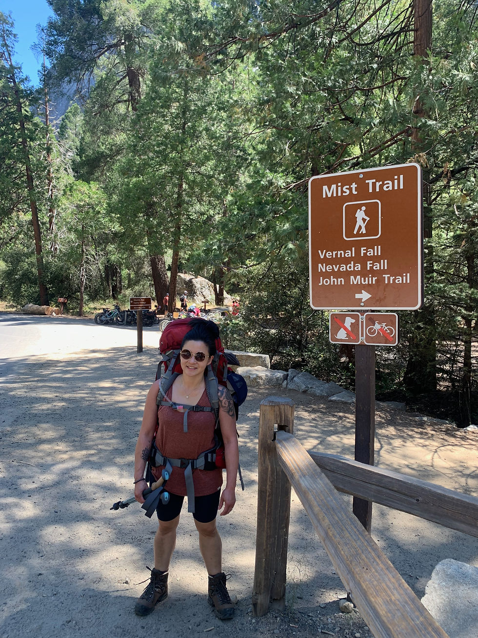
From Happy Isles, follow signs to Mist Trail. The first section is paved and runs along the Merced River. It is the busiest part of the trail with day hikers and other tourists.


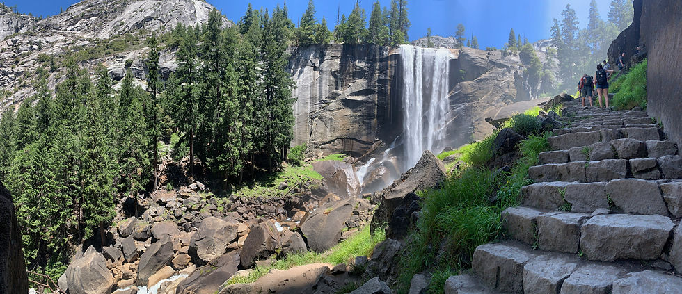
Soon, you will reach the start of the long uphill grind toward Vernal Falls. Basically, a Stairmaster made of stones. This was one of those moments where I questioned all the life choices that brought me here, but then I take a look at those falls and it's a real motivator 😎.
Just keep steppin'!

A few steps more...
Top of Vernal Fall - elevation gain (via Mist Trail): about 984 ft (300 m)
Distance: 1.2 miles (2 km).


Next stop, Nevada Fall, another uphill leg grinder!


Top of Nevada Fall - elevation gain (from trailhead via Mist Trail): 2000 ft (610 m)
Distance: 2.7 miles (4.3 km)

Onward to Little Yosemite Valley Campground
Original first night plan: Wilderness camp 1 mile outside Little Yosemite Valley Campground (where our permit allowed).
Instead: We didn't make it to the Little Yosemite Valley area until much later in the day than planned and had to camp there for the night.
Little Yosemite Valley

For those continuing onto Half-Dome, this will be the last water source. If heading up to the campground, there will be access to another water source from Sunrise Creek.
Little Yosemite Valley Campground.
Our permit did not allow us to camp at Little Yosemite Valley Campground but we talked with a Park Ranger that let us stay the night. We were SO relieved - it would have been another mile uphill hike before our permit would allow us to set up camp. My legs and knees were screaming all sorts of things at me! This campground is also your last spot for pit toilets on the trail.


Day 2 - Camp along Sunrise Creek
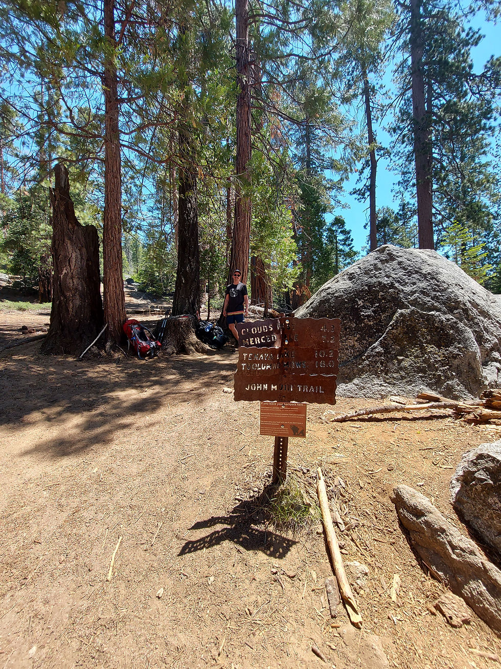
Original Day 2 itinerary: Summit Cloud's Rest, and disperse camp north of the summit. Camping at the summit is prohibited and there are no designated campsites at Clouds Rest, but we read somewhere that there is a spot to camp on the south side of the mountain about half a mile from Clouds Rest and 200 feet west of the main trail. Keep in mind, there is no water source at, or near, Clouds Rest so plan for enough water accordingly.
Instead: We took it easy on ourselves today - It was our honeymoon trip after all! We hiked to the Clouds Rest Trailhead and camped just beyond the junction along Sunrise Creek. A total distance of about 2.1 miles (3.4 km).
Closer to reaching the Half Dome trail, things get even steeper as you climb some switchbacks. However, the JMT after the junction gave our legs a nice break and offered easier terrain and beautiful views of the surrounding mountains.

Sunrise Creek - at elevation 8100 ft (2469 m)


At the Clouds Rest/JMT junction, passing hikers informed us of a forest fire in Mariposa Grove (known as the Washburn fire) about 30 miles away. We didn't know how far the area was from us at the time but we found spotty cell reception and were able to monitor the fire's growth on InciWeb. We then learned of a few smaller fires in the areas around us. In the photo above, you'll notice a smokey slight red/pink haze in the distance. All this made us hesitant about continuing our multi-night journey! Within the next 24 hours, the fire in Mariposa Groove, home to over 500 mature Giant Sequoias, had grown from 433 acres to 766 acres with zero containment🥺. It wasn't fully contained until Aug 3, at 4,886 acres.
Based on conditions the next morning, we would either embark on a day hike to Clouds Rest and extend our stay by another night, or simply descend on day 3.
Day 3 - Day Hike up to Cloud's Rest
Original Day 3 itinerary: After camping near Clouds Rest, hike to Upper Sunrise Lakes and camp for 2 nights.
Instead: No thru-hike for us this time around. When we looked at InciWeb, the Washburn Fire was still not contained and growing very quickly. Though far from us, I still found it unsettling. So we adjusted our plan: a day hike to summit Clouds Rest, followed by one more night before heading out of Yosemite the way we came in.
Here we go, Clouds Rest Summit!


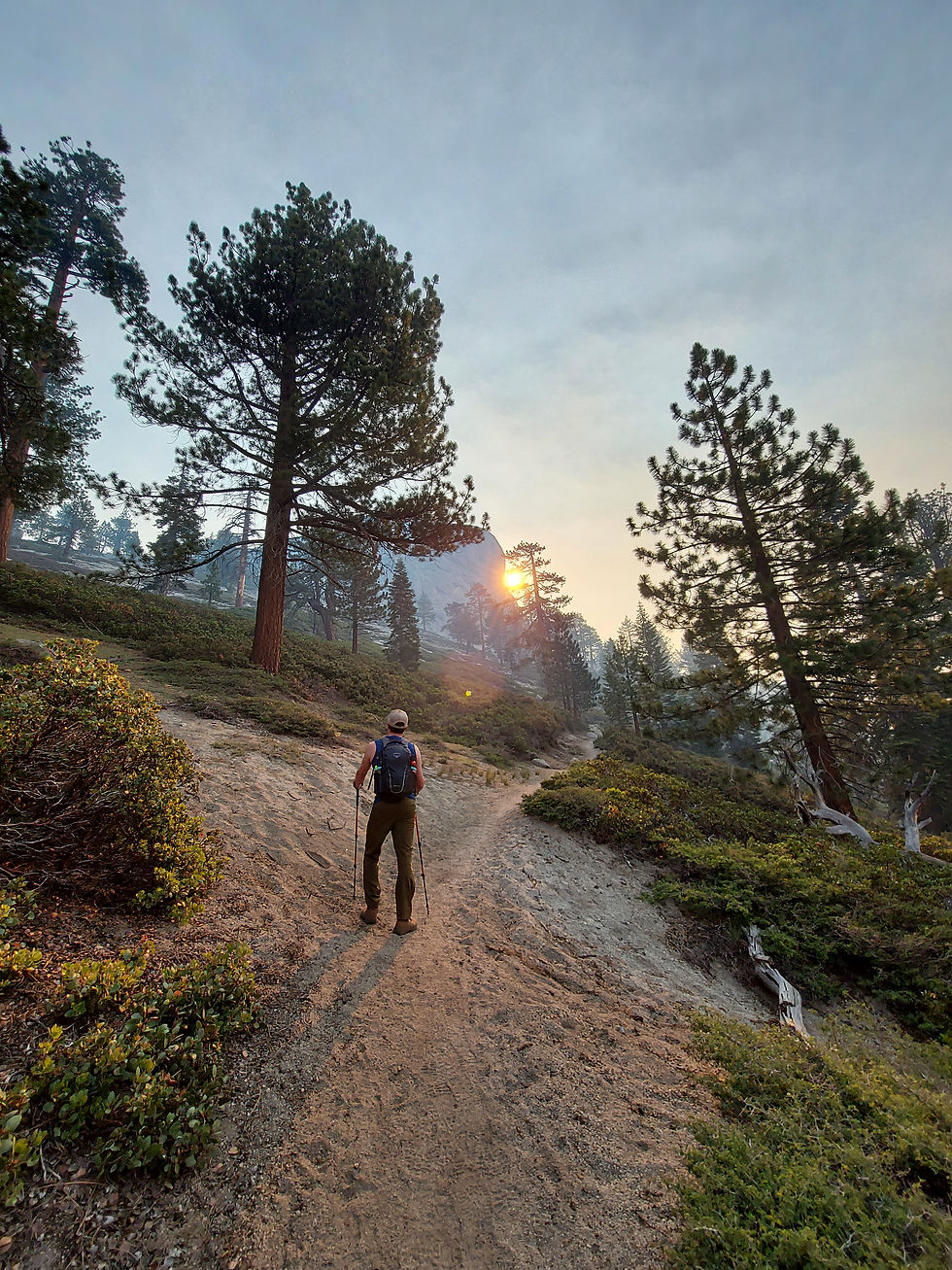

1.1 miles from Clouds Rest, the trail becomes rocky.

Leads you to this incredible lookout. Smokey conditions, but still caught a stunning view of Yosemite.

The next sign is the 0.6 miles mark (about 1 km) to Clouds Rest! Prepare for sun-exposed trails in this last section.

Almost there!

Getting closer... view of the trail looking back down.

The trail starts to get steeper and narrower, with some steep drop-offs. If you are shaky with heights, I wouldn't recommend looking down at this point!
Clouds Rest Summit!
Although the smokiness covered much of the view we were hoping for, the trail up was beautiful and still worth it for the 360-degree panoramic view of Yosemite National Park we caught from the summit!


Fun fact: there is cell reception up at Clouds Rest Summit! This worked out really well for us. Since we were leaving 2 nights early from Yosemite, we decided a road trip to San Fran was fitting and we proceeded to book our hotel accommodations at 9,926 ft elevation 😎.
Heading back down to our camp:


When we returned to camp, the smoke in the area was much heavier, the sun was giving off an eerie red glow all around, and we noticed ash starting to fall across our tent.
New plan: We made the call to hike out this day. Staying the extra night just wasn't worth the uncertainty and stress, and the fact our vehicle was parked between us and this growing fire.
The Return to Happy Isles from Sunrise Creek
This hike was strenuous! Talk about pushing my limits, clocking in at nearly 15 miles (24 km) in a single day. On the return to Happy Isles, we had one mission: get to our vehicle before dark to avoid driving down that stretch of Highway 140 without guardrails at night. This left us with less than 4 hours to cover 7 miles (11.2 kms) back to the Yosemite Valley Trailhead Parking Lot. As it was mostly downhill, things got really tough on our back and knees while still carrying 3 extra days' worth of food and snacks!
Route: Clouds Rest Trailhead - Nevada Falls - John Muir Trail back to the Mist Trail/John Muir Trail Trailhead. Taking the John Muir Trail adds extra kilometres but the trail is the much less steep option vs. the Mist Trail.


Our photo-taking took a backseat from this moment on. We were so hyper-focused on getting off the trails before dark. But we did it - we made it back to the parking lot in the nick of time! However once we were ready to go, we weren't able to escape the night drive down the highway.
Next challenge: the scramble to find vacant accommodation during the peak summer season. This brought us to Sonora, California about 2 hours away. Super lovely and charming city. Would definitely visit Sonora again and, of course, Yosemite!


Comments