Juan de Fuca Trail: Botanical Beach to Mystic Beach - Vancouver Island, BC
- Camilla Ho
- Feb 15, 2024
- 15 min read

Updated: Jan 12, 2025
We've shifted gears away from the alpine and now exploring the trails in our coastal backyard of Vancouver Island. The Juan de Fuca trail is one of the most popular backcountry hikes in BC, and it's a challenging one. This 47-kilometer wilderness trek along the Pacific coastline of the Strait of Juan de Fuca proved to be more demanding than expected; bursting my very naive idea that a coastal hike would be easier than our alpine hikes. There is so much happening on this trail - there's deep mud, uneven terrain, unmaintained sections, broken and slippery infrastructure, surprise wasps' nests, tide-dependent ocean crossings, short and sweet but constant elevation changes, lunging steps, a lot of pulling my weight up things or jumping off things, and thoughts of "Is this part of the route?". Looking back, it's a classic Type B fun trail. I didn't always love the trail at times, but I now laugh at the experiences and lessons learned. And gained a lot of insight for next time; so yes - I would 100 percent hike the Juan de Fuca again. It was a beast, but a stunning beast of a hike it was!
Along the trail, there are both forested and beach campgrounds to choose from. Choose your adventure!
Beach sites: Mystic Beach, Bear Beach, Chin Beach, and Sombrio Beach.
Forest sites: Little Kuitsche Creek (limited shoreline access) and Payzant Creek (no shoreline access). Campfires are not permitted at these sites. Between the two forest sites, we chose to camp at Payzant Creek. It was significantly denser with greener foliage and shrubs giving sites more privacy from one another, which we preferred.
The entire hike takes about 3-5 days, depending on how hard you want to work. I recommend completing the trail in 4 nights/5 days. It's still a challenging hike but the hiking days are not as long, and you will ultimately have more time to just enjoy the journey and watch the ocean wildlife!
If you don't have the time to complete the full 47 km route, there are 4 trailheads to access at different points on the Juan de Fuca Marine Trail: Juan de Fuca East (China Beach), Sombrio Beach, Parkinson Creek, and Botanical Beach (see trail map below).
If you need to exit the trail at other points along the Juan de Fuca Trail:
Around the 25 km marker, the trail intersects with an unmaintained/forest service road. Instead of continuing east on the trail toward Chin Beach, take the path heading north that leads to Highway 14.
There are exit trails that leave from behind both Chin Beach campsites to Highway 14. The trail is about 1.2 -1.3 km from either campsite to the highway. Elevation gain around 210 m.
At Bear Beach (east of Clinch Creek), there's an unmarked exit trail called "Bear Beach Trail" from the Juan de Fuca (I didn't see any signage for this, but it does show up on Gaia GPS). This trail connects to a forest service road leading to Highway 14. The exit trail is approximately 1.3 km to Highway 14. Note, that many online reviews highlight the difficulty of staying on trail and strongly suggest using GPS.
Here we go!
Juan de Fuca Trail, Juan de Fuca Provincial Park, BC
Camping itinerary: Payzant Creek, Sombrio Beach (East), Chin Beach, and Bear Beach
Highest elevation point: 187m

The Juan de Fuca Marine Trail is located on the ancestral and traditional lands of the Pacheedaht First Nation, surrounded by giant rainforest gems: Western Hemlocks, Sitka Spruces, and Western Redcedars (provincial tree of B.C.).
Gear wish list:
- Ear plugs for the ocean waves. You'd think it would be amazing white noise - just not so much when the ocean is only a few metres away from your tent.
Personal lessons:
- A solid understanding of the Beach Cut-Offs Chart in conjunction with the trail tide schedule.
Respect the park and tips for backcountry camping:
- Follow Leave No Trace principles - pack out whatever you pack in
- Use the bear caches provided
- Follow park and camp regulations
- Protect sensitive vegetation by staying on the trail and respecting trail markers and out-of-bound areas.
- Do not feed any wildlife - it's a risk to people and wildlife.
- There are no greywater disposal units at any of the campgrounds. Pack out all your food bits and dispose of the grey water at least 70 m from camp or water.
Getting to the trailhead
Directions:
If you are planning this trip as a hike-thru, you can enter from either end at these trailheads:
Botanical Beach Trailhead (at Kilometre 47 km; West to East route). About 6 minutes from Port Renfrew, BC - head southwest on Parkinson Rd toward Cerantes Rd. Turn right onto Cerantes Rd and follow the road until you reach the Juan de Fuca Trail Trailhead (Northwest/Botanical Beach) parking.
Juan de Fuca East (China Beach) Trailhead (at Kilometre 0; East to West route). About 35 minutes from Sooke, BC - head northeast on Juan de Fuca Hwy/Sooke Rd/ BC-14 E. At the roundabout, take the 5th exit onto Juan de Fuca Hwy/Sooke Rd/BC-14 W. Follow the BC-14 to Juan de Fuca Trail Trailhead (Southeast/China Beach).
Many reviews of this trail out there say Botanical Beach to Mystic Beach is the less strenuous route - this was the route we hiked.
Parking:
Both trailheads offer ample parking spots. However, these trailheads are very popular so I would still recommend getting there early. Limit the valuables left in your vehicle, as instances of theft are known to be relatively high at these trailheads. There are outhouses found at both parking lots.
Permits and shuttles:
The trail is open year-round, but backcountry permits are required. You can secure your permits through BC Parks up to 2 weeks before your hiking dates.
Shuttle services between trailheads are available. However, I recommend arranging your shuttles in advance of obtaining your permits. At the time of securing our permits, all the shuttles were already fully booked and we had to come up with an alternate plan for getting between trailheads.
Juan de Fuca Marine Trail Map and Distance Chart:

Image source: BC Parks
Day 1 - Botanical Beach to Payzant Creek
Distance: 7 km; Max. Elevation - 91.1m | Min. Elevation - 14.3m
A nice and leisurely Day 1, this section of the hike took us about 3 hours. At the start, you'll find numerous interpretive panels that delve into the cultural and natural heritage of the area. And while there's some elevation change throughout, it's not until you approach Payzant Creek that you begin to climb in more forested terrain.
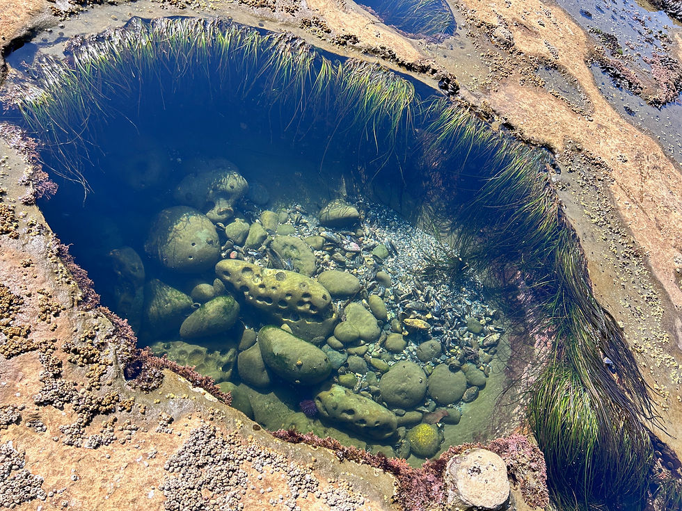
Before hitting the trail, carve out some time to check out the tidal pools at Botanical Beach before the tide comes in. You'll find a spectrum of marine life within them - we saw starfishes, sea urchins, sea anemones, and blue mussel shells to name a few!
Botanical Beach

Start of the trail:

The trail starts at the information board, just before it splits off for the beach access.

In the first few kilometers of the trail, you'll come across numerous scenic viewpoints with awesome ocean views.


The type of hike that defines most of the Juan de Fuca trail - aged infrastructure and intricate paths intertwined with tree roots. A very unique charm to the trail!

Tom Baird Creek, named after a pioneer of Port Renfrew. Following this is a short beach section before re-entering into the forest.

The orange balls mark the exit from the beach, leading you back onto the forest trail. From here, you will cross another two creeks (Soule Creek and Yauh Creek) before reaching Payzant Creek.
Photo drop!
More pictures of old infrastructure along the trail and incredibly scenic lookout points of the Juan de Fuca Strait!


Payzant Creek Campground
At Kilometre 40; Elevation: 75.6m


A forested campground with well-built camp pads, two outhouses, a food cache, and a creek for water access. Despite lacking shoreline access, I loved the vibrant green lushness and low shrubs at Payzant Creek, which gave a lot more privacy between sites. The creek at Payzant wasn't as full of clear running water during our stay. But, if needed, Yauh Creek is a water source just 1 km west along the trail.
Day 2 - Payzant Creek to Sombrio Beach
Distance: 10.4 km (Payzant Creek to Sombrio Beach Main)
Max. Elevation - 74.4m | Min. Elevation - 11.5m
This section took us about 5.5 hours to complete - categorized as a moderate hike taking you through forest and shoreline trails. Along the way, you will pass Parkinson Creek and Little Kuitshe Creek Campground.
Payzant Creek to Parkinson Creek: 3km
Payzant Creek to Little Kuitshe Creek: 7km


Leaving Payzant Creek, the trail starts with a trek through some more aged and weathered infrastructure through the forest.


In about 0.6 km the forest trail begins to open up and you will start to see ocean views again.

Between the Kilometre 39 and Kilometre 38 markers, you can hike along the reef shorelines at low tide. Watch for the buoys or orange balls hanging from trees to signal you back onto the forest route.
From Kilometer 38 to Parkinson Creek, things were looking a little moody in the forest...

The abrupt shift from ocean views to this part of the trail was a bit of a shock; almost eerie especially when you're the only ones on the trail. I was starting to wonder if we took the wrong turnoff (or missed a marker to continue along the beach)... until we saw the sign for Parkinson Creek about 0.6 km up ahead. This photo was taken at 8:45 in the morning, but the lighting and mood made it feel like early evening hours. No photo filter on this one, this was how my phone captured this section.
Parkinson Creek to Little Kuitshe Creek: 4 km

Parkinson Creek Trailhead and Parking: access point between Highway 14 and the Juan de Fuca Trail. An outhouse is available at Parkinson Creek.


We noticed a lot of new infrastructure and ongoing boardwalk projects after Parkinson Creek - it was a refreshing change on our feet! We could still smell the fresh lumber and see the dry sawdust along the trail. 2023 upgrades to the Juan de Fuca Trail
Snack Break at Little Kuitshe Creek Campground
At Kilometre 33; Elevation: 25.6 m
From Payzant Creek, it took us approximately 3 hours to hike to Little Kuitshe Creek Campground. We weren't overly impressed with this site, to be honest. But if your aim is to cover more distance on Day 1, it could serve as a good first campsite. Notably, the camp pads were extremely close to each other, providing minimal privacy (Little Kuitshe Creek didn't have the same denseness of low-growing foliage and shrubbery as compared with Payzant Creek). Higher up, there were a few camp pads but they were quite close to the outhouses. However, the water source at Little Kuitshe Creek was much clearer and plentiful than what we had at Payzant Creek!
Onwards to Sombrio Beach
From Little Kuitshe Creek to Sombrio Beach, the hike was mostly tree-covered. In terms of difficulty, I'd rate it a moderate to challenging hike. This section of the trail had a lot more elevation changes throughout, and the slippery worn-out infrastructure always made things more interesting. But, for me, it was the noticeably greater number of massive steps to haul myself up, down, or climb over!

800 meteres from Little Kuitshe Creek, you'll reach the Minute Creek Suspension Bridge. Once you are on it, enjoy views of the Juan de Fuca Strait!
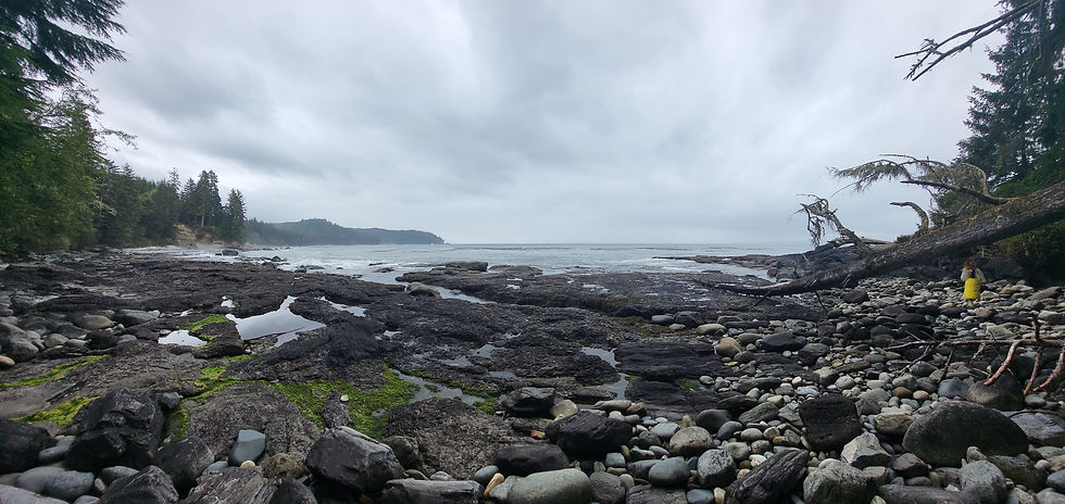
As you approach the beach opening, the next roughly 1.5 km of the trail runs alongside the open waters of Juan de Fuca Strait. Pay close attention to the tide and tide schedule here. Depending on which camp you want to stay at on Sombrio Beach, there are a few tidal points along the beach trail that are impassable at high tide.
Sombrio Beach (West): KM 30.2 - Passable if tide height is below 3 metres. (If you miss the opportunity to pass, there is a 0.5 km alternate route through the forest before exiting back onto the beach path).
At Sombrio Beach (Main): KM 29.6 - Passable if tide height is below 2.6 metres. (If you miss the opportunity to pass, you will need to wait until the tide is out again. Or, you can hike back about 0.2 kilometre. We didn't go back to check it out but Gaia GPS shows a short alternate route through the forest before exiting back onto the beach).
Sombrio Beach (East): KM 28.0 - Passable if tide height is below 3 metres.
We almost didn't make it... it was a King Tide too...


Storytime: Happy optimism quickly shifted to an expression of "What just happened...!" Our plan was to camp at Sombrio East, and although we were pushing it close to high tide, we decided to go for it. Then... I hiked through an ocean. The tide was rising quickly, leaving no time to debate whether or not to take off our hiking shoes. Next thing I knew, I was nearly waist-deep in the ocean, maneuvering around a rocky cliff. This undoubtedly ranks as one of my most adrenaline-filled hiking experiences - just trying to maintain balance on the rocks and avoid toppling with my pack into the crashing waves against the cliff!
But almost to camp, yay!

Cross the suspension bridge over the Sombrio River, and you'll find the West Sombrio Beach campsite just 0.1 km ahead.
Sombrio Beach (Kilometre marker 29)
We didn't encounter many people on the trail until we reached Sombrio Beach – it was a sudden jolt to my system and senses! The stretch along Sombrio was abuzz with activity, teeming with people – a hotspot for surfers, tourists, day hikers, and campers.
Sombrio Beach Trailhead serves as one of the access points along the Juan de Fuca trail, with a parking lot located about 0.2 km from the beach access.
There are 3 campsites: Sombrio West, Sombrio Main, and Sombrio East.

Sombrio (West) Campground
At Kilometre 30; Elevation: 25m
Located 0.1km West of the suspension bridge crossing Sombrio River and Sombrio Beach Trailhead. There is an outhouse and bear cache at the site. If you are looking for more distance from crowds, this is not your site.
Sombrio Main Campground
At Kilometre 29; Elevation: 38.1m
The first campsite east of the suspension bridge crossing Sombrio River, and links to the Sombrio Beach Trailhead and Parking. You'll find this section bustling with surfers, day-hikers, and campers set up above the rocky slope along the beach. There are outhouses and bear caches within easy walking distance. If you are looking for more distance from crowds, this is also not your site. But if it's to enjoy watching the surfers out there, this is your spot!
Sombrio (East) Campground
At Kilometre 27; Elevation 17.7 m
Located about 0.4 km East of Sombrio River, and closest to the start of the trail heading towards Chin Beach. An outhouse and bear cache is within easy walking distance. If you are looking for a bit more space from others, this is your spot. It is still a well-trekked area but it's probably the calmest of the 3 campsites.


Day 3 - Sombrio Beach to Chin Beach
Distance: 6 km (Sombrio Beach East to Chin Beach West)
Max. Elevation - 197.5m | Min. Elevation - 0m
Even though it's just 6 km, I'd rate this section as... challenging. There's a lot of navigating diverse terrain, along with decent elevation gains compared to earlier days. All this, while syncing with the tide schedule – two points along the trail become impassable at high tide. Whether you choose the coastal or alternative inland route, the second tidal challenge comes right before reaching Chin Beach. After covering about 3 km along the trail, we found ourselves hustling. Admittedly, we opted for a bit of sleep-in on this day to soak up more of the morning beach vibes, so that was kind of on us.
The trail that keeps on giving, ocean views and all! This stretch demands lunging steps, testing your leg flexibility (which might not be a big deal if you're taller than me, which is likely). Throw in countless deep mud patches, big tree root systems to navigate up and down, and some decaying infrastructure to always keep things interesting.
Beach route or forest route:
From the Loss Creek Suspension Bridge, the next access to the beach trail is approximately 1.1 km ahead. After that, it's about a 1 km hike along the beach to reach Chin Beach. If you're concerned about the tide coming in, take the inland route instead of the beach, and continue for an additional 0.6 km until you reach the second beach access point. If the tide has rolled in, you'll have to wait before continuing. From there, it will be around 0.4 km to Chin Beach.


Giant and beautiful old growth trees 🌲❤️ ❤️


Loss Creek Suspension Bridge and view


The many stunning lookouts to Juan de Fuca Strait!


Chin Beach (West) Campground
At Kilometre 21; Elevation: 15m
I loved Chin Beach. It had an intimate, quaint, and cozy feel, and it's an incredible spot for watching seals and sea lions live their best life. There were camp pads set up further away from the shoreline but we continued with our beach set up on the rocky, sloped edge. We wanted a spot away with a bit more isolation in case the site got busy. And the tide had already peaked so we felt safe enough with our tent being so close to the shoreline.
Facilities-wise, Chin Beach Campground has two outhouses, a bear cache, and a creek to fill up on water.


Watching the sunset at Chin Beach - it was incredible!
Chin Beach (East) Campground
At Kilometre 20; Elevation: 28m
The only thing about this site is the absence of a water source, except at Chin Beach (West) Campground. There's one tidal point between these two sites that becomes impassable during high tide, requiring you to wait until low tide to refill water.

To reach Chin Beach (East) Campground, hike about 1 km East along Chin Beach from the West site. You'll find Chin Beach (East) Campground just up this staircase. What caught my eye about this site was the beautifully constructed camp platform that overlooks right above the Juan de Fuca Strait.
Day 4 - Chin Beach to Bear Beach Campground
Distance: 12 km (Chin Beach West to Bear Beach)
Max. Elevation - 214.8m | Min. Elevation - 11.8m
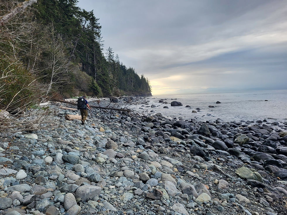
I'd rate this hike on the more challenging end, taking us about 4.75 hours to complete. There were some moderate sections, but overall it was a true workout due to mud, seemingly never-ending elevation gains and drops, and sections of "How does this work?" and "Is this the actual trail to climb up?" type questions. The elevation changes were relatively short but consistent throughout the trail – as soon as you went up, you'd come straight back down. (Imagine a little squiggly drawing of waves). There were also many fallen trees that I had to hurl myself over, but I enjoy that kind of stuff 🙂.


Bear Beach (Kilometre marker 9)
Our final night on the Juan de Fuca! Three camp areas that span along Bear Beach: Rosemond Creek, Clinch Creek, and Ledingham Creek. There is a tidal point along Bear Beach at Kilometre 8.7 that becomes impassable at high tide (passable below tide height at 3 metres). Keep this in mind if you plan to camp at Rosemond Creek (Bear Beach East).
Ledingham Creek camp area
Around 10.5 km point; Elevation: 40.8m
The first camp area at Bear Beach hiking East and home to the famous Rock-on-a-Pillar. We didn't stick around too long to look around so I can't say too much about the camp area. I think because our goal was to get to Bear Beach East, we just wanted to continue before the tide came in.


Clinch Creek camp area at Bear Beach (West)
Around 10 km point; Elevation: 12.8m
We found an amazing sandy spot a bit tucked away from things and ended up setting up camp here! There were 2 outhouses, a food cache, and the creek was a decent water source. On the other side of the creek, there were camp pads if you prefer not to set up camp on the sand.


Rosemond Creek camp area at Bear Beach (East)
Around 8.2 km point; Elevation: 20.7m
As we hiked through Bear Beach (East), we both thought this would have been a great spot to camp as well. There was also a much better creek as a water source.
Day 5 - Bear Beach to Mystic Beach
Distance: 9 km (Bear Beach West to Juan de Fuca East Trailhead)
Max. Elevation - 125m | Min. Elevation - 12.5m
I rate this hike as an easy-to-moderate time. The section took us about 4 hours to complete, with stops to soak in so many ocean views on the trail (couldn't get enough of it!) and sea lion spottings on our last day. We also just spent time hanging out at Mystic Beach before hiking to the trailhead (KM 0). If you didn't make any significant stops along the way, the entire way back to the trailhead would probably take 2.5-3.5 hours to complete.


There is a big ladder and staircase that leads you out of Bear Beach (East) and onwards to Mystic Beach. Shortly after this staircase is the Kilometre 8 marker.


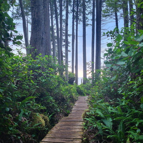
The rest of the hike took us through a lush and beautiful forest with a few views of the ocean, and this very cool log bridge.
Mystic Beach (Kilometre marker 2)
The hike from the Mystic Beach Trailhead and Parking Lot is relatively easy. There are a few sets of staircases leading down to the beach, which can be tough on the knees, especially with a heavy pack. But then you are met with this beautiful beach to obsess over! Given its proximity to the parking area, you'll come across many day hikers and people just enjoying their lunch with a view.

Mystic Beach Campground
At Kilometre 2; Elevation: 18.6m
Mystic Beach is a great option to camp for a little easy-peasy overnight nature escape. We counted at least 10 wooden tent platforms tucked away in the forest - and at least 1 with a pretty good view of the ocean. We also spotted a few areas where you can set up on the beach. It has 2 outhouses and a bear cache to store food.

Onwards to Mystic Beach Trailhead and Parking


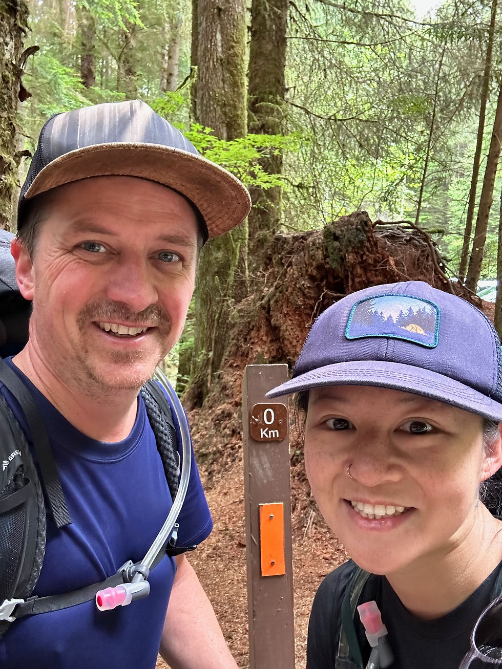
And we're back! Kilometre 0!
This multi-night adventure truly tested my patience and love for the outdoors! It was a rollercoaster of emotions, encompassing moments of happiness, tranquility, adrenaline, being high off nature, pain, and frustration. Why? I hiked through an ocean, trudged on with wet socks and boots for three consecutive days, was the target of a painful wasp sting, took a hard branch to the face, and even managed to hit my head on a fallen tree in a moment of distraction maneuvering over a log. But amidst all the challenges, it was an incredibly rewarding hike with breathtaking sunsets on the horizon and the chance to traverse through really cool old-growth forests. And that has a unique way of leaving an unforgettable mark on the soul ❤️.


Comments