Rain, Thunderstorms, and Good Friends - An epic multi-night trek to Beatrice Lake, BC
- Camilla Ho
- May 7, 2023
- 7 min read

Updated: Jan 12, 2025
Newly obsessed with the Valhalla ranges, we went back for more the following year after our trip to Gwillim Lakes. This time, we easily convinced a group of friends to join us. The original plan was to bring them to Gwillim Lakes but the 2 feet of snow in early July brought on a bit of a challenge that we weren't quite prepared for!
So here we go!
Beatrice Lake via Slocan-Evans Creek, Emerald Lake, and Cahill Lake inside
Valhalla Provincial Park
Elevation: 1443m

Located within the traditional territory of the Secwepemc, Ktunaxa, and Syilx First Nations, another breathtaking part of southeastern BC tucked away alongside creeks and lakes.
Gear wish list:
- Bigger tarp
- Compact sleeping mat
- Compact shovel (TMI warning: out-of-order outhouses were a theme during this trip)
- Hydrapack for better water weight distribution
Personal lessons:
- Not to attempt this hike back to back after a solid week of other trails and backcountry hikes (that was way too much grind for my legs)!
- Better knowledge of alpine winter seasons
Respect the park:
- Follow Leave No Trace Principles and camping ethics
Getting to the trailhead
You will first need to hike the 8.1 km Slocan-Evans Creek trail to Evans Creek Campground. You can also access this campground via boat/kayak/canoe. If you choose to hike, the trailhead starts about 500m past the Slocan-Evans Trail parking in the city of Slocan, BC. Walk across the creek on Park Ave towards Slocan West Rd, then take a right at Slocan West Road until you reach the trailhead. This trail is beautiful and well-maintained with open views of Slocan Lake. Get ready for a lot of up and down terrain, as well as a few boulder slide crossings (can definitely see these sections getting incredibly slippery if raining).
Directions: Enter the city of Slocan, BC from Highway 6. The parking area is at the corner of Park Ave and Main St.
Parking: The parking area might look a bit confusing because it's just a grassy area at the corner of Park Ave and Main St. I was a little uncertain when we reached the lot, but our vehicles were still there when we returned from the hike :)
Day 1 - The hike to Evans Creek Campground
Slocan-Evans Creek trailhead to Evans Creek Campground: 8.1km (3-4 hours with our pack weight). For a lakeside hike, the trail to Evans Creek Campground was a lot tougher on the legs than expected. It was a continuous series of short inclines and descents, some actually quite steep, weaving through trees along Slocan Lake. Gorgeous hike though! Definitely take time to soak in the open views of Slocan Lake along the way. The campground had many camp pads, a shelter (with at least 4 sleeping pads), picnic tables, bear caches, campfire rings, and pit toilets (though they were out of order during our trip).
Our journey:

I just love this photo. One of the many short inclines as you continue on the trail weaving through the tall trees, with Slocan Lake to the right.

One of the many fallen trees across the trail to climb over that summer. For those that are 5 ft tall like me, there is just no graceful way of doing it with a pack 😎. Only a few kilometres in and already scratched up good. If there is a graceful way doing this with your pack... teach me your ways!

Our friend captured this photo as we crossed one of the many boulder fields along the Slocan-Evans trail. As we journeyed through, we experienced all sorts of weather changes. It couldn't make up its mind, holding in store for us a steady pattern of overcast skies, gentle drizzles, and bright bursts of sun.

But it saved the best for last - the torrential downpour that hit us upon reaching the camp! It lasted a good chunk of time so we hid and hung out in the unoccupied campground shelter. The sudden onset and amount of rain that covered the camp was incredible. I honestly loved it though - the sheer force of it all was intimidating and beautiful.

An evening with friends and camping. When the rain let up and after setting up camp (can't remember if we took a swim as well on this first day), we settled in at one of the beach spots to hang out and cook. Ended up being a gorgeous night!
Day 2 - Lunch at Emerald Lake and Onwards to Cahill Lake Campground
Evans Creek Trailhead to Emerald Lake: 4km hike (3-3.5 hours with our pack weight), with an elevation gain of 500m. Make your way upward from Evans Creek campground towards the steel bridge crossing Evans Creek. Once you cross the bridge, you get immediately warmed up with an uphill trek.

This photo was taken just before the bridge. We took a moment to admire how roaring and powerful the water was as it flowed down the creek, crashed against rocks, and gobbled up any forest debris in its path.

About 1.5km into the trail. My favourite part about this trail was hiking beside creeks like this, and being completely hypnotized by the impressive volume of sound it generated.
Emerald Lake


After 3-3.5 hours of steady hiking, the trail opens up to Emerald Lake! It felt so peaceful here. It helped that we were also the only ones in the campground. We rested, we enjoyed, we ate, we dipped our toes. If you choose to camp here, there are 4 tent pads, an outhouse, and bear caches.
Onwards to Cahill Lake
From Emerald Lake to Cahill Lake (east end) is about 2km, and to Cahill Lake (west end) where the camp pads are is an extra 1.5 km. This section of the hike to Cahill Lake campground took about 2-2.5 hours with our pack weight, with an elevation gain of around 215m. At this campground, there are 6 well spaced out tent pads, 2 outhouses, and bear caches.
There were 4 very memorable moments and adventures along this section of the trail - the bridge, the hill that made me question all the life choices that brought me here, Cahill Lake (east end), then the thunder rolling in.

The bridge. After hiking a bit from Emerald Lake, you will reach this cool bridge that crosses Beatrice Creek. While crossing, you can't help but feel a little adrenaline kick in as your being guided across by a single wire cable. Still, I took a moment to take it all in, turning at one point with my backpack facing the cable, and be completely mesmerized by the force of the water rushing below me. I absolutely love these creeks! 🤗

The hill that made me question all the life choices that brought me here. The hill that also made me wish I had a jetpack instead of a backpack! It was quite the steep big thing. I read about the steepness from other blogs and just thought, power through as usual - all good. But this one got me good! There were a few flattened areas to take some breathers but they were almost no use to me. I was a panting sweaty mess lol.
Cahill Lake

Cahill Lake (east end). Such a gorgeous lake and backdrop. And worth every step of the grind that got us here! Follow the trail another 1.5 km to the camping spot on the west end of the lake.

The thunder rolling in. Aside from grizzly bear and cougar encounters, hiking in thunder is right up there as one of my biggest fears in the backcountry. Thick dark clouds were enclosing above us, the last 1.5km of the trail up to Cahill Lake (west end) was mostly lined with tall thin trees swaying side to side, I was hearing cracking in the distance, the temperature got moist and humid, and the sounds of thunder around us. We took fewer breaks and we H-U-S-T-L-E-D.

Cahill Lake (west end), and the bridge that leads you to the camping area. Our arrival couldn't have been better timed. We got to camp, found some open spots, quickly set up our tents, and just as we finished, the rain dropped harder and thunder came. We got snug and cozy under my tiny tarp, made some instant noodles, had some beverages, and waited it out.

The early evening glow of Cahill Lake ❤️ - So stunning. The fog adds a perfect touch of eerie beauty.
(Tangent storytime: I woke up to the sounds of a very large animal at dawn - slow, heavy footsteps accompanied by the snap of branches and the unmistakable sound of hoofing. I don't think my heart has ever pounded so hard as it did then. I still don't know what it was outside my tent, but my instincts told me to stay put, listen, and not move a muscle! It was a strange feeling of intense fear yet exhilaration. Whatever it was, it went away eventually and I did my best to fall back asleep🙂).
Day 3 - Day hike to Beatrice Lake
From Cahill Lake to Beatrice Lake is about 2.5km (1.5-2 hours with our day packs) and an elevation gain of around 215m. There is no camping allowed at Beatrice Lake, and no pets beyond this point.
Beatrice Lake

I love the Valhallas so much. It's views and backdrops like these that make every step worth it. Crystal clear water, a beautiful day. We hung out, swam, floated, and paddled riding on a log to that tiny islet you can kind of spot on the right side of this photo.

In my element and pure joy!
A few photos heading back to Cahill Lake campground


An old washed-out bridge.
Onwards back to Evans Creek Campground
When we returned to Cahill Lake, we packed up all our stuff and began heading back down to Evans Creek Campground. This ended up being quite a grueling hike after the day hike up to Beatrice Lake. As it was mostly downhill, it got really hard on my knees, toes, legs, glutes... pretty much everything - especially shortly after leaving Emerald Lake.

The hike from Cahill Lake to Beatrice Lake, then all the way back to Evans Creek Campground was an undertaking! I remember being completely wiped by the end of this day. But we're back at Evans Creek Campground with a prime beachfront spot! Waking up to Slocan Lake, clear skies, and that crisp morning air was a great way to start the next morning.
Day 4 - Our return to Slocan via the Slocan-Evans trail
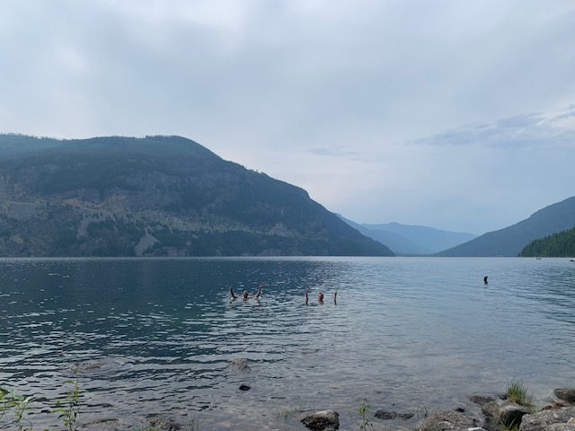
A morning swim before heading back to Slocan, even though the weather changed quickly on us.

Taking one last moment to look out at Slocan Lake, and a classic group shot.

Rain, thunderstorm, and good friends - it was an absolute blast and so grateful for this crew who are always up for anything. However, I think I can speak for all of us when I say that there was likely a collective sigh of relief when we finally caught sight of the trailhead. For me, my legs were feeling like jelly and possibly about to stage a rebellion - at the same time, ready to run to some burgers and beer. And that's exactly what we did!
Checkmark for our first group hike together and hopefully more to come!


Comments